Erosion processes on intensively farmed land in the Czech Republic: comparison of alternative research methods
Bořivoj Šarapatka and Patrik Netopil Department of Ecology and Environmental Sciences, Palacký University, tř. Svobody 26, 771 46 Olomouc, Czech Republic, Email: borivoj.sarapatka(a)upol.cz
Abstract
VSoil erosion and deposition of sediments are natural processes caused, in CZ conditions, by water and wind. However, these processes are also increasingly affected by human activity in the countryside. Research in the cadastral area of Čejkovice in South Moravia, CZ, where typical chernozem is the dominant soil type, showed problems typical for large areas of such soil type and similar farming intensity. To evaluate the extent of erosion two alternative methods were used – digital visual image interpretation and classification of areas of erosion from aerial photographs, as well as measuring radionuclide 137Cs in soil samples. Before using these methods a model of potential erosion within the area was created, using the Universal Soil Loss Equation (USLE). The outputs of the research were compared in terms of exactness, general suitability and dis/advantages of different approaches. The application of remote sensing data, together with a field survey, seems to be very prospective and effective.
Key Words
Erosion, aerial photographs, visual image interpretation, image classification, radionuclide 137Cs, field survey.
Introduction
Soil erosion and deposition of sediments are natural processes caused, in CZ conditions, by water and wind. However, these processes have also been increasingly accelerated by human activity. In the Czech Republic erosion is a serious problem: about 50% of arable land is endangered by water erosion and 10% by wind erosion (Janeček 2007; Šarapatka et al. 2002). Soil is a non-renewable natural resource; therefore its degradation due to surface erosion has far-reaching environmental and economic consequences. Moreover, the extent and impact of erosion is not just a local problem, neither is it a problem of a few recent years. It often means irreversible changes, taking place over decades, without adequate solution. Besides degrading the soil, erosion also reduces soil fertility and crop yield, causes pollution in both surface and ground water sources and increases sedimentation of loosened material in fields, alluvial meadows, river basins and water reservoirs where it contributes to water eutrophication and contamination (Zapata 2002).
Methods
Čejkovice area in South Moravia, CZ, was chosen as the pilot area for studying water erosion, its dominant soil type being typical chernozem which reflects the problems characteristic for large areas of such soil type and similar farming intensity.
The following methods were used to evaluate the extent of erosion: A widely used method of modelling potential erosion, using the USLE equation (Wischmeier and Smith 1978). Processing the input data from the studied area was simplified by using geoinformatic methods. Commonly available commercial ArcGIS software was used for a GIS model of potential erosion. As an alternative approach, digital visual image interpretation and classification of areas of erosion from aerial photographs. Visual evaluation of photographs is based on vectorization, i.e. drawing borders of eroded areas directly in the software environment. Aerial photographs were used in mapping earlier, but only the development of IT and geographic information systems enabled relatively fast and exact analysis of this type of data from Earth remote sensing (Fulajtár 2001). Preparation of photographs, orthorectification, creating seamless orthophoto mosaic and image analysis (unsupervised image classification) were carried out in ERDAS IMAGINE program.
Another, alternatively used method was that of field survey – measuring the amount of 137Cs radionuclides from soil samples in an transect, perpendicular to the slope affected by erosion. The estimation of 137Cs redistribution is generally based on comparing the measured values of this radioisotope (total activity per unit area) in a certain sampling point (soil sample) with reference value representing cumulative atmospheric fall-out on the site (Zapata 2002).
Results
In this part we present only two research methods, i.e. visual image interpretation and classification, and the method of measuring radionuclides, both of which we have compared with the classical method for studying erosion.
Visual image interpretation and classification
In an aerial photograph, an erosion-disturbed soil profile is shown as a set of light areas of variable intensity on a darker background (on extreme sites even the opposite). The main problem of such a method can be in the vegetation cover (crops) of the area. Visibility can be improved by e.g. adjusting contrast. Another option is a combination of a higher number of time-spaced images where the affected areas are plant-free. The presence of special vegetation such as vineyards, orchards or hop-fields are specific to fertile warm areas where the affected areas can be adequately detected by manual-visual interpretation. Despite being time-consuming, non-objective and having deficiencies, this technique is quite exact. Its non-objective character is the result of the spatial complexity of the erosion process, creation of colluvisols and the limited possibility for an exact interpretation of the colour shades with the human eye. Defining non/eroded areas can be subjective, especially on a large-scale map.
Automation of several phases is an advantage and, in some respects also a disadvantage of the process of undirected image classification (Lillesand et al. 2007). This often means that areas are marked which have nothing to do with erosion, the operator cannot directly intervene in the process. However, objectivity of results is an undoubted advantage – the results should be identical when using identical software data and classification.
Generally, the exactness of the identification, compared with visual interpretation, is of a very good standard. A combination of field survey, consideration of topography – a digital terrain model and the use of analytical tools of directed image classification can further improve - thus various stages of degradation could even be distinguished. This could eliminate the afore-mentioned disadvantages of interpretation. Another advantage of automation is in rapid processing, the option of working with large areas of land and practically excluding subjective evaluation of data. An exact detection of spectral characteristics (colour shades) of every single pixel of an image is another plus as this is not possible in other methods.
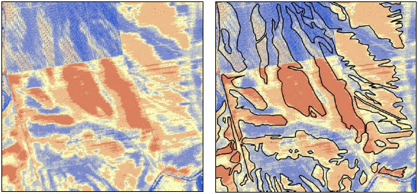
Figure 1 and 2. A layer of land analysed via unsupervised classification; right: projection with a visual interpretation vector layer.
Radionuclide measurement method
Large scale measurement of radionuclides is hardly feasible and generally demanding, from the sample-taking phase to evaluation of results. Creating erosion maps is also more difficult in comparison to classic field survey (Fulájtar 2000). The undeniable advantage is in the possibility to monitor soil erosion dynamics, both in time and in the soil profile. This allows the realistic estimation of the cubic volume of material moved by erosion.
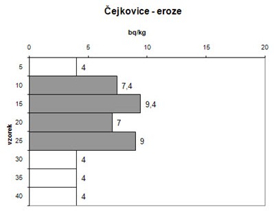
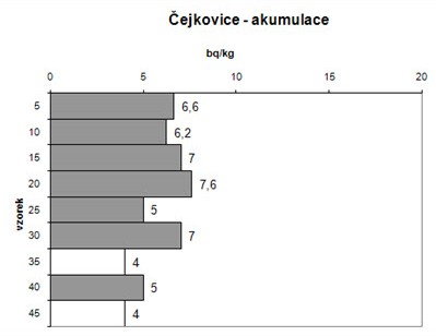
Figure 3 and 4. The distribution of Cesium in the soil profile confirms the advanced stage of the coluviation process (erosion), when the older layers without measurable radioisotope content cover younger layers with traces of 137Cs deposited within about 40 years.
An accumulative sample shows increased surface horizon and reduced radionuclide content in the soil profile due to erosion and consequential deposition of sediments (soil).
The results provide a relatively reliable estimation of the extent of soil redistribution within the last 40 years. The computerized data obtained is compatible with current mathematic models, GIS applications and geostatic methods dealing with loss or accumulation of soil (Harmon and Doe 2001). This method combined with a field survey allowed the verification of results of the methods described above. The main goal was to consider alternatives of field work with the real state of soil.
Conclusion
Knowledge of the spatial layout of eroded areas is an important condition for effective soil protection, particularly against the effects of water erosion in an intensively farmed landscape. Still, relevant information on such a degradation process is often not mapped in detail. The research showed that the classic research methods can be successfully supplemented with results of the afore-mentioned methods, especially visual interpretation and classification of aerial photographs. Application of remote sensing data is very prospective, although a certain amount of subjectivity in processing such data (vectorization) must be resolved, as with the final specification of results of automated unsupervised image classification. Both approaches are being developed at present and their deficiencies should be suppressed while the spectrum of advantages is developed.
The results of all so-called GIS methods can be verified in detail and compared to field survey supplemented by soil sampling and consequential measuring of 137Cs radioisotope content, on the basis of which the erosion dynamics can be evaluated throughout the soil profile and partly in a time scale.
Acknowledgement
The authors of this contribution would like to express their thanks to the Czech Ministry of Education, Youth and Sports and the Czech Ministry of the Environment for supporting this research via 2B06101 and VaV1c/4/8/04 Grants, and also to Doc. RNDr. Jiří Zimák, CSc., for his co-operation in analysing 137Cs radionuclides.
References
See the article in PDF format (link below)